ACREAGE: 200
Explore the trails
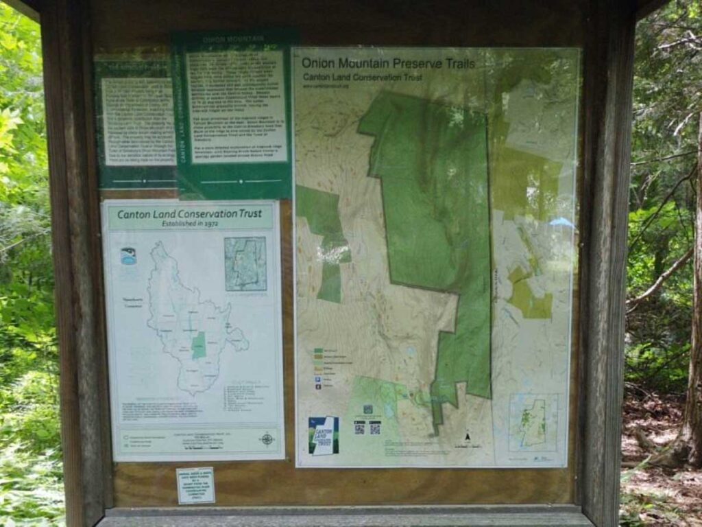
The 200-acre Onion Mountain Park preserve comprises eight parcels, Joe D. Pratt Onion Mountain Preserve, Stitch, Korder-Bredahl, Corey, Arnold, Jepsen, Brewster, and Yakemore-Porritt. The preserve is home to three trails:
1. The Blue Trail, which is accessed from the Roaring Brook Nature Center Orange Trail
2. The Blue-Orange Trail, which is accessed from the Simsbury Onion Mountain Blue Trail
3. The Green Trail, which connects the Blue-Orange Trail to the Blue Trail
The first two trails both go to the Onion Mountain Ridge, while the third trail serves as a connection between the two.
Blue Trail
- Blazes: Blue
- Duration: About 0.7 miles out and back, including the orange trail
- Difficulty: Moderate, with a steep section attaining the ridge
- Trailhead: Roaring Brook Nature Center, on the east side of Gracey road
- Features: A small brook, and magnificent view at the top of the ridge
Blue-Orange Trail
- Blazes: Orange with Blue Dots
- Duration: About 2.0 miles out and back, if starting near Lostbrook Road
- Difficulty: Challenging with a steep section attaining the ridge
- Trailhead: A small pull-off near Lostbrook road (see more detail below)
- Features: magnificent view at the top of the ridge
Green Trail
- Blazes: Light Green
- Duration: About 1.0 mile from the Blue-Orange Trail to the Blue Trail
- Difficulty: Easy, although the access to either end is moderate
- Trailhead: Roaring Brook Nature Center, on the east side of Gracey Road or a small pull-off near Lostbrook Road
- Features: A nice connection between two older trails, creating the opportunity for a more extended hike
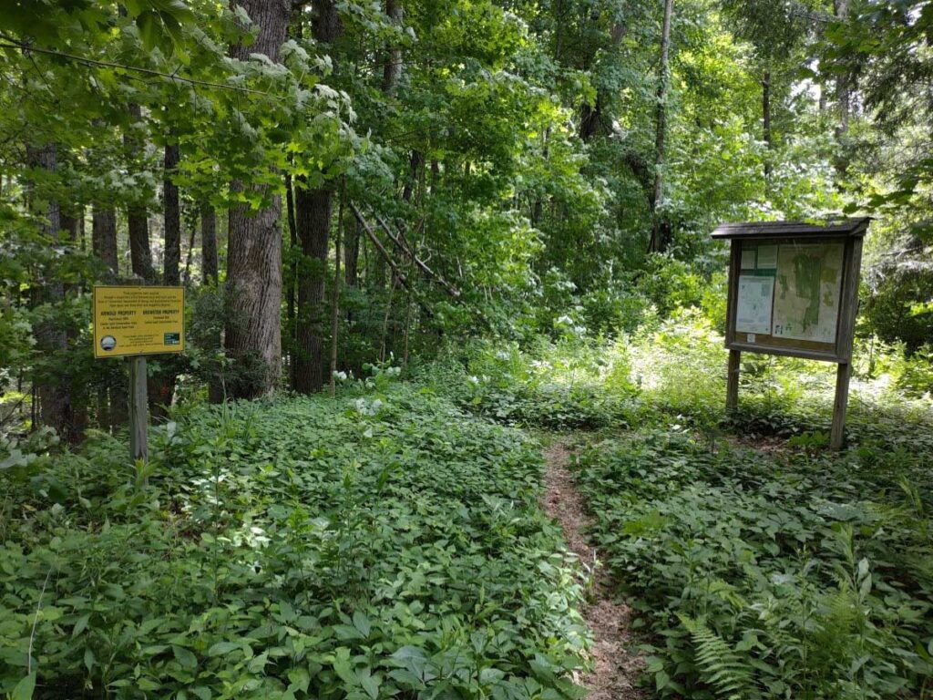
Dog Policy
- Dogs on or off leash must be under control and close to the trails at all times.
Please be considerate to other hikers and trail neighbors - clean up after your dog and take litter with you.
Directions & parking
Blue trailhead:
The trailhead for the Land Trust Blue Trail is located across the street from the Roaring Brook Nature Center parking area. The entrance to the parking area is located at 70 Gracey Rd. Go into the driveway, go past the main building and park close to the end. You will have to cross the road and walk past the picnic tables to access the beginning of the Orange Trail. In Google maps you can search for "Onion Mountain trailhead"
Blue-Orange trailhead:
The best way to access the Blue-Orange Trail is to start at the southern end of the Blue Trail on West Mountain Road. There is no full parking area, just a small pull-off alongside West Mountain Rd.
In many mapping services (such as Bing, MapQuest and Google maps), you can enter the latitude and longitude of the location: 41.855, -72.867
In Google maps, you can search for Onion Mountain Blue trailhead.
If driving north on West Mountain Rd., the location is 1/10 of a mile north of Lostbrook Road.
If driving south on West Mountain Rd., the location is 3/10 of a mile south of Quorn Hunt Road.
The trailhead on the west side of the road will not be easy to spot, but there is a better defined parking area for a trail into the Massacoe State Forest almost immediately across the street from the access to the Simsbury Blue Trail. You can be sure you are in the right place if you see a green and orange metal bar at the entrance to the Simsbury Blue Trail. Blue blazes can be seen on nearby trees.
Follow the blue trail for approximately 0.4 miles until you reach the intersection with the Blue-Orange Trail. Then follow the Blue-Orange Trail, which starts in Simsbury but crosses over into Canton and Land Trust property. The trail from that point on begins to climb progressively uphill to the summit where there is a magnificent view to the east which includes a sighting of Heublein Tower.
History of the property
In 1974, when the land trust only held two parcels of land, Andrew and Edith Yakemore began discussions about a gift of land in memory of their son. One challenge was that the property in question was landlocked. This access problem was solved when Mr. and Mrs. Longshaw Porritt donated an access corridor connecting the Yakemore property to Gracey Road. The gift of the two properties was completed in 1975: the combined properties are referred to as Yakemore-Porritt (sometimes Porritt-Yakemore).
The Stich property was acquired in 1992. It had been acquired by the town of Canton in 1985 in lieu of back taxes; the stewardship and ownership were transferred to the land trust in October 1992.
The Pratt (Nature Conservancy) parcel was acquired in 1993. This area was acquired with the assistance of the Nature Conservancy of Connecticut, Inc. The property had been preserved as open space and was owned by the Nature Conservancy but in 1993, they agreed to transfer the stewardship and ownership to CLCT. This 100-acre property borders Gracey Road on the west and the Stitch property on the east. This property contains part of a trap rock ridge and is home to the long-leafed bluet (Houstonia lonifolia), a flower on the state endangered species list.
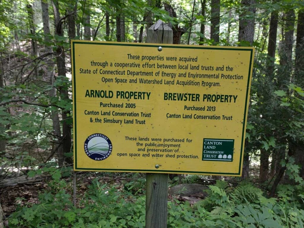
The board began looking at the Arnold property in 2003 and completed acquisition in 2005 with help from the DEEP open space grant and with significant financial assistance from the Simsbury land trust. The eastern border of this 68-acre property is the Simsbury-Canton town line while the northern border abuts the Stitch property.
In late 2000, Walter Korder and Florence Bredahl gave the land trust a 90.5-acre parcel of land, located just east of Gracey Road, bordered on the north by the Pratt parcel and on the northeast by the Stitch parcel.
The land trust acquired the 15-acre Corey property in 2011. This property nicely filled in a notch, with Korder-Bredahl to the west, Stitch to the north and Arnold to the east.
In 2013, the Brewster family bifurcated their property and sold the western 5-acre portion to the land trust. This parcel is beautiful in its own right but it also nicely linked the Yakemore-Porritt parcel on its western border to the rest of the Onion Mountain properties at a point in the northeast corner.
In 2019, we completed a transaction that had been in the works for years, to transfer 10 acres of property from the Jepsen family to the land trust to meet open space requirements for a possible development. This parcel borders both Yakemore-Porritt and Brewster on its southern border and Arnold on its eastern border.